|
|
|
|
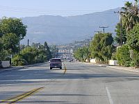
The GIS aspects of processing the data are discussed elsewhere. This article is about evaluating GPS receivers. The objective is to identify units that can be used with a minimum of system preparation: portable, low-cost, rugged receivers that work with PDAs rather than laptop computers (the requirement for working with PDAs is not really a burden on the GPS; it is usually a matter of appropriate cabling, but vendors could help by offering the right accessories). Of course the ultimate test is coordinate accuracy, which in the following article is discussed in 2 dimensions only.
This is not a comprehensive survey of market offerings in GPS hardware.
Many of the products reviewed here will be obsolete in a year or two. Although
selected models are critically evaluated, the purpose of this article is
not to review them comprehensively, but to illustrate how products might
be evaluated and compared for the purpose of centerline survey, and to outline their
most relevent capabilities and usability issues.
| Note: Vehicles engaged in tests such as these have a high accident rate. We strongly advise against any active operation or even observation of GPS logging units while driving, regardless of driver experience. A number of safety precautions were observed during these tests, that are not detailed here. |
 |
|
and Handspring Visor, running CetusGPS |
The drawback of the Companion arrangement is that, because it completely takes over the serial port of the Visor (although it physically uses the Springboard slot), it is not possible to feed in a real time differential correction signal. In fairness it could be argued that the applications for which this hardware is designed do not require D-GPS accuracy.
Most GPS software products for the Palm/Visor receive and perhaps display NMEA inputs, but it is difficult to find one that stores the data. An excellent product is CetusGPS, available free from Kjeld Jensen of Denmark. CetusGPS compresses the data as it is received, storing essential elements of each NMEA record — time, position and altitude, speed, heading, HDOP — in a mere 28 bytes, permitting 50+ hours of logging in the 8Mb of Visor Prism memory (note that memory expansion is not an option because the Companion uses the Springboard slot). Palm/Visor buttons are programmed to access the principal menu items, so navigating the menu in a vehicle is quick and easy. Aside from a compass rose, Cetus displays little information useful to a driver, so it does not pose much of a distraction.
Cetus is not specific to any GPS model, hence it does not switch on the GPS receiver — Magellan's software must be invoked to do that, and then Cetus must be launched before the receiver switches itself off.
Unfortunately the hardware combination has significant problems:
 |
|
|
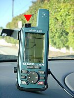
The unit has 4 contact points on its back, which serve as (1) power supply, (2) NMEA output, (3) RTCM differential input. A single data/power connector covers all four contacts. Again the gap between good product design and poor support becomes apparent. Magellan sells a connector cord that supplies power from a vehicle, and downloads data through a serial plug. But it is not possible to input the differential correction and download NMEA data at the same time. It's not clear whether this is just a matter of the right cord not being made available (a bare-wire connector is), or a system design deficiency. The power/data connector snaps neatly into the back of the windshield mount, so the GPS slips in and out easily without any explicit connector handling. However, after a couple of hot days in the vehicle, the spring clip (see red arrow in photograph) is no longer able to hold the receiver in the mount, and it takes a bit of Velcro to secure the GPS in place thereafter — an unlikely juxtaposition of space age technologies. The MAP330 itself is rated for operation up to 60°C, and our unit has shown no sensitivity to temperature.
For our tests we fed NMEA output from the MAP330 into a laptop computer, and logged the data using Hyperterminal. Logging could probably have been achieved on the Visor, with special cabling.
The MAP330, like many other receivers in its class, can store a limited amount of tracking data, and Magellan offers MapSend software that transfers the data from the receiver to a computer. But this is so poorly implemented that it has no practical value. MapSend has little functionality of its own, yet it stores the data only in its proprietary format, making it unavailable for further use. Although the MAP330 is designed for recreational hikers rather than road surveyors, 3 simple changes would make it the data logger to beat:
 |
|
|
The iGPS-180 generally has a good usable design. The antenna and processor are combined into one light, small-footprint unit which can be placed on a dashboard and tethered to the windshield using the suction cup provided (a magnetic mount for exterior use would have been useful). The cable from the unit splits into two plugs, one DB-9 serial for data, the other a PS/2 keyboard plug that ingeniously draws power from the computer's external keyboard input port. The Visor-specific cable, an extra, matches the Visor serial port and uses a cigarette-lighter plug for power. Incredibly, the Visor cable supplies power only to the GPS, not the Visor, despite taking over the Visor power/serial port. This is a serious impediment to extended use, bearing in mind that Visor power consumption is much heavier than normal when the serial port is in operation. The iGPS-Visor combination cannot match the convenient 1-piece integration of the Magellan GPS Companion, but it does allow the antenna-processor to be positioned independent of the Visor.
As in the case of the MAP330, NMEA data from the Pharos were logged using Hyperterminal on a laptop computer rather than the Visor.
A drawback of the minimalist design of the iGPS-180 is its lack of a display or any status indicators. Our iGPS-180 failed after a few months of use, perhaps due to heat in the vehicle (although it is rated to 80°C). It now outputs NMEA fields with null data.
 |
|
|
|
|
Like the other GPS receivers described above, the Placer records GPS data at approximately 1 Hz.
 |
|
|

(a) |
(b) |
(c) |
(d) |
|
|
|||
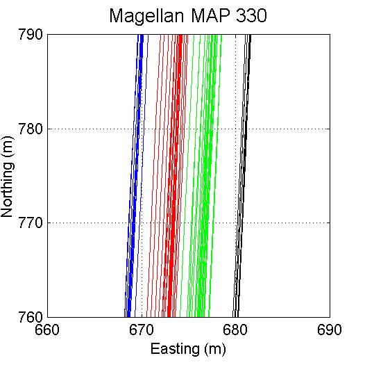
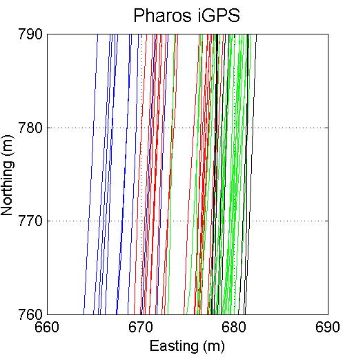
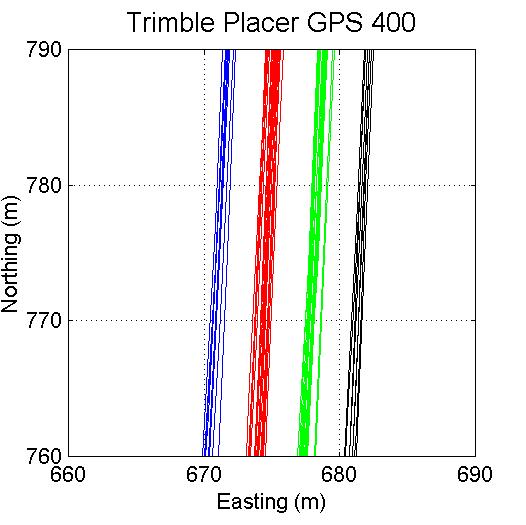
Predictably, the differentially corrected Trimble reference unit (d) produces the tightest readings. The GPS Companion (a) is a surprising second, edging out the WAAS-enabled MAP330 (b). The Pharos (c) is significantly inferior to the other models. These results are consistent with stationary tests, where the Trimble showed the least drift, and the Pharos the most. Since we do not know whether or how readings are averaged internally by the receivers, the stationary tests by themselves are not good indicators of suitability for road survey.
How much repeatability/accuracy is enough? This is application-dependent. For routine navigation, GPS position and centerline geometry can be within 20-25 m and be acceptable. For emergency applications, where one needs to know whether an incident is in the north-bound or south-bound carriageway of a divided highway, 5-10 m accuracy is more appropriate. For highway maintenance, assets such as guard rails are recorded with 10-15 m accuracy.
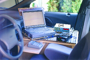
Highway operators typically reference locations in terms of linear measures. For coordinates to be compatible with linear referencing, centerline coordinates must be linearly consistent. Analysis of GPS tracks for this purpose is the subject of other UCSB research. On most roads, linear measures derived from centerline coordinates from GPS units above are within 0.25% of DMI measurements, which is close to the limit of DMI calibration accuracy.
| D-GPS | Differential GPS. In the U.S., differential signals are broadcast free by the Coast Guard in coastal areas, and a Nationwide Differential GPS broadcast is under development. |
| DMI | Distance Measuring Instrument. Odometer with ~1 m resolution, employed in highway operations. |
| HDOP | Horizontal Dilution Of Precision. Dilution of Precision is a function of satellite configuration, and is a rough indicator of the quality of GPS reading — a value of <2.0 is good. When satellites are temporarily obscured, the statistic measures the effectiveness of the remaining configuration, which is usually not as good, so DOP is roughly correlated (inversely) with the number of visible satellites. Generally speaking, DOP is directly proportional to error, but there are situations where a configuration may yield a poor statistic but good coordinate accuracy, and less frequently vice versa. |
| NMEA | National Marine Electronics Association. NMEA 0183 version 1.x and 2.x are standard formats by which GPS receivers communicate position and satellite configuration data. |
| PDA | Personal Digital Assistant: handheld computer such as the Palm and Handspring Visor. Compaq/HP and other vendors offer equivalent models. |
| RTCM | Radio Technical Commission for Maritime Services. RTCM SC-104 is the standard format for feeding differential correction data to GPS units. |
| TAIP | Trimble ASCII Interface Protocol |
| VITAL | Vehicle Intelligence and Transportation Analysis Laboratory, UCSB |
| WAAS | Wide Area Augmentation System, a Federal Aviation Administration sponsored GPS enhancement, originally intended to assist aircraft navigation in poor visibility. WAAS-enabled equipment should be capable of about 3 m accuracy. But signal reception is a problem. Only two INMARSAT satellites currently transmit WAAS signals over North America, hence reception is spotty. The NMEA format version 2.x (implemented in the above receivers) does not indicate whether WAAS is being received and processed. |
All trademarks are the property of their respective owners.
| 2002-08-21 |