An efficient transportation network plays a crucial role in the overall development of a nation’s economy. India, like many other countries, has recently experienced rapid economic and social change, but much of this growth has been concentrated in major cities. A high priority of the government is to now to provide better transportation infrastructure for a large number of isolated villages, which have until now been served only by footpaths, cart tracks and seasonal roads. A major concern is how to allocate available resources incrementally and most effectively, to achieve maximum efficiency of the resulting road network. To address this need, we are developing a decision support system that is capable of identifying the most cost-effective way to upgrade and rehabilitate transport connections.
|
|
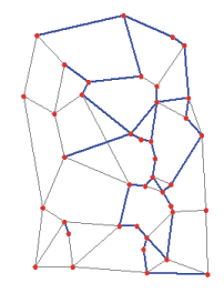
| Figure 1. Solution emphasizing
higher traffic flow volume. |
Researchers at the University of California, Santa Barbara are developing
a decision support methodology to assist in the planning of rural road network
upgrades. The first stage of the project aims at improving village connectivity
in rural regions by selecting road segments to be paved. A network optimization
approach has been developed, which finds the optimal (or close to optimal)
pavement strategy given the current availability of funds. The efficiency
of the strategy is evaluated in terms of two important criteria:
1. the proportion of inter-village traffic volume that is
served by paved roads
2. vehicle kilometers traveled (VKT) between connected villages.

|
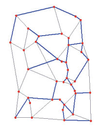
| Figure 2. Solution emphasizing traffic
flow efficiency. |
Depending upon the weighting assigned to each parameter, different pavement
strategies are generated that reflect the relative importance of the two
goals.
For example, Figure 1 and 2 show two possible solutions obtained by giving
greater importance to the first goal (traffic flow) or second goal (VKT),
respectively. The red dots represent villages. The thin gray lines depict
dirt roads while the heavy blue lines show candidate paved sections. With
more importance placed on traffic flow covered by paved roads, the first
solution connects all but three villages. The entire traffic flow volume
covered by paved roads equals 99% of the global traffic flow on the network.
By contrast, the second solution covers only 92% of the traffic flow volume
but improves on the VKT measure by a full 35%.
This second solution demonstrates that rural village connectivity by itself
may not be efficient without considering traffic patterns and demand. Such
model tools can aid in efficient allocation of scarce road development resources.
The second stage of the project will be devoted to exploring multi-period planning problems. Commonly, road development takes place over more than one building phase. Our methodology will be extended to account for multi-time period rollout operation.
Richard Church, church@geog.ucsb.edu
Paola Scaparra, paola@ geog.ucsb.edu
University of California, Santa Barbara