|
|
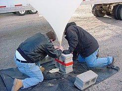
| Figure 1. Preparing for launch |
As part of a research project testing remote sensing applications,
a team from the ISU Center for Transportation Research and Education (CTRE)
team is exploring the use of tethered balloons as platforms for data collection.
Part of the research effort is learning about the many logistical issues
involved with ballooning, such as weather, cost, equipment, planning, safety,
etc. Still images can be captured in color, black and white, and
near infrared, and video imagery can be captured in digital and film formats.
The research team also plans to explore the use of thermal imagery.

|
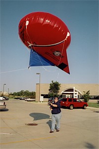
| Figure 2. Launching the helikite |
To learn how to use balloons as a potentially viable platform for transportation
data collection and surveillance, CTRE partnered with the ISU HABET Team
(High Altitude Balloon Experiments in Technology). HABET is part of the
Spacecraft Systems and Operations Lab (SSOL) of NASA’s Iowa
Space Grant Consortium.
There are several advantages to using balloons for data collection.
One of the most significant advantages is that balloons could be deployed
quickly and data collected immediately. For instance, balloons could
be sent up to record traffic operations during a special event.
Balloons may also be able to collect data that traffic-monitoring cameras
cannot. Most traffic monitoring cameras are stationary and mounted
in specific locations. They are limited in the height at which they
can be located, by practical constraints. Tethered balloons can be
moved and located easily, providing a more flexible method to collect data.
Additionally they can be launched and realistically used up to several
thousand feet so data can be collected over a wide area.
Potential uses of the balloons include observing driver behavior such
as merging behavior on freeway ramps and car-following, evaluating safety
problem areas, supporting infrastructure data collection, and monitoring
locations such as bridges, for critical infrastructure protection.
|
|
| Figure 3. Balloon shot from 1000 ft |