|
|
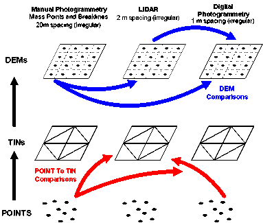
| Figure 1. Overview of comparison methodology. |
As LIDAR is a relatively new spatial technology, standard procedures have not been developed to yield data with predictable accuracy comparable to current photogrammetric technologies. As a result, LIDAR has not been readily adopted by state DOTs for engineering design projects requiring accurate elevation data.
Researchers evaluated LIDAR data in comparison with current photogrammetric methods. Using data provided by Iowa DOT, comparisons were performed among elevation surfaces derived from analytical plotters (i.e. mass points and breaklines), LIDAR and automatic extracted points from digital aerial photography (i.e., softcopy points), for a highway evaluation corridor in eastern Iowa. The methodology for these comparisons is illustrated in Figure 1. Comparisons between elevation points and Triangular Irregular Networks (TIN) and comparisons of Digital Elevation Models (DEM) for three large-scale features (i.e., drainage ditch, gully and bridge) and small-scale areas of mixed land use (i.e., mostly farmland, farmland with roads and farmland with roads and residential) were performed. These comparisons were to verify LIDAR elevations and softcopy elevations with manual data, to identify potential elevation differences based on feature type and land use and to identify LIDAR data density and gaps in areas with sharp edges in elevation.
|
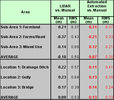
| Table 1. Elevation differences between LIDAR and softcopy points with manual data. |
Research results, summarized in Table 1, provided an initial assessment of LIDAR and an assessment of digital photogrammetric data compared with LIDAR. Preliminary results indicated that for small areas, differences between LIDAR with manual data agree with vendor quoted elevation accuracies (i.e., 10-15 cm, or ~6 in). Results also indicated that elevations from automated surface extraction methods are as good as, if not better than LIDAR-generated elevations, compared with manual photogrammetric data. Sharp elevation edges of features (i.e., drainage ditch, gully and stream crossing) in this research can be used to identify and quantify potential directional shifts (i.e. x/y errors) in LIDAR data (currently unsubstantiated). Research results indicated that difference variability tended to be lower using automated extraction methods than using LIDAR for all comparison regions. Elevation difference surfaces indicated that automated extraction data appear to produce smaller differences with manual data than LIDAR data on natural features and farmland (see Figures 3 and 4). Preliminary results also indicated that differences in LIDAR data seem to produce definable patterns based on land use. For example, in areas where breaklines exist (e.g. roads, streams), elevation differences are consistently larger (see Figure 3). LIDAR point density was fairly regular and did not show any gaps or missing areas. However, the LIDAR data set used in this research did not clearly identify sharp changes in elevation at culverts and stream edges.
|
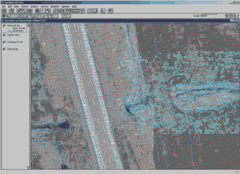
| Figure 2. Orthophoto of gully with LIDAR (red), softcopy (cyan) and manual (yellow/blue) points. |
These initial research results are being used to identify methods of improving
the accuracy of LIDAR by technology integration and to identify methods for
reducing editing time of automated extracted data. NCRST researchers are
investigating the potential benefits in blending photogrammetric technologies
for production of low cost, engineering design-level elevation data. The
blending of automated photogrammetric techniques and LIDAR should produce
highly accurate terrain models with minimal editing. Automated digital photogrammetric
techniques tend to produce inconsistent results that require extensive editing.
LIDAR tends to produce higher uncertainties in horizontal positions than
photogrammetric methods. Using LIDAR as an initial approximation for digital
photogrammetric matching, the number of failed matches should be considerably
reduced; thereby minimizing required manual editing time, a significant cost
factor. Additionally, these enhanced automated extraction methods can be
used to fill in LIDAR gaps at comparable accuracies, allowing agencies to
specify greater LIDAR point spacing at a cost savings. Initial research results
indicate that LIDAR-enhanced automated extraction techniques can produce
elevation data closer to manual methods with less variability than using
LIDAR or automated extraction alone. These results also indicate that LIDAR-enhanced
automated extraction data produce almost identical elevation differences
to the manual data set when LIDAR point spacing is doubled or tripled.
|
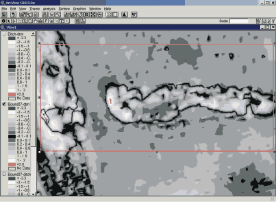
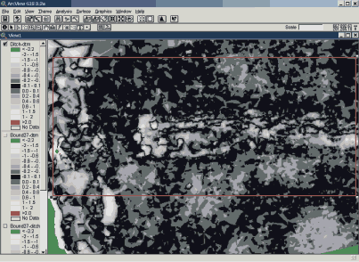
Figure 3.
Elevation difference surfaces between LIDAR and manual data for gully show
definition of gully and roadway (Black areas indicate smaller elevation differences). |
| Figure 4. Elevation difference surfaces between softcopy and manual data for gully indicate smaller variation. |